Pelee Island Airport (CYPT) — Pelee Island
Pelee Island Airport (CYPT)
CYPT
Pelee Island Airport (CYPT)
Pelee Island,
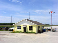
Latest photo of Pelee Island Airport (CYPT)
Chris Wilson
Pelee Island Airport (CYPT) is a public-use airport located in Pelee Island. The airport sits at an elevation of 571 feet above mean sea level. It features 2 runways. The gallery includes 1 photo of operations and aircraft at the airport.
| FAA Information Effective | 2026-09-03 |
| Airport Identifier | CYPT |
| Airport Status | Operational |
| Longitude/Latitude |
82°40'41.0000"
W /
41°46'42.0000"
N -82.678056 / 41.778333 (Estimated) |
| Elevation | 571.00 ft / 174.04 m (Estimated) |
| Location | Ontario, Canada County, CN |
| Magnetic Variation | 07W () |