Duluth International Airport (DLH)
Duluth International Airport (DLH)
DLH
Duluth International Airport (DLH)
Duluth, MN
Latest photo of Duluth International Airport (DLH)
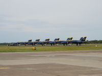
Mitch Sando
| FAA Information Effective | 2026-09-03 |
| Airport Identifier | DLH |
| Airport Status | Operational |
| Longitude/Latitude |
92°11'35.6540"
W /
46°50'31.4511"
N -92.193237 / 46.842070 (Estimated) |
| Elevation | 1427.80 ft / 435.19 m (Surveyed) |
| Land | 3020 acres |
| From nearest city | 5 nautical miles NW of Duluth, MN |
| Location | St Louis County, MN |
| Magnetic Variation | 01W (2020) |
| Airport Use | Open to public |
| Wind indicator | Yes |
| Segmented Circle | No |
| Control Tower | ATCT-TRACON |
| Beacon Color | White-Green (lighted land airport) |
| Landing fee charge | Yes |
| Sectional chart | GREEN BAY |
| Region | AGL - Great Lakes |
| Responsible ARTCC | ZMP - MINNEAPOLIS |
| Tie-in FSS | PNM - PRINCETON |
| FSS on Airport | No |
| FSS Toll Free | 1-800-WX-BRIEF |
| NOTAMs Facility | DLH (NOTAM-d service available) |
| Certification type/date | 1973/05 |
Runway 03/21
| Dimensions | 5719 x 150 ft (1743 x 46 m) |
| Surface | ASPH (GOOD) |
| Surface treatment | Saw-cut or plastic Grooved |
| Edge lights | Medium |
| 03 | 21 | |
|---|---|---|
| Alignment | 32° | 212° |
| Physical elevation | 1413.70 ft | 1416.00 ft |
| Coordinates | 46.835741 / -92.188270 | 46.849103 / -92.176312 |
| Traffic pattern | Left | Left |
| Runway marking | Non-precision instrument , Good Condition | Non-precision instrument , Good Condition |
| VGSI | 4-light PAPI on left | 4-light PAPI on left |
| Runway end lights | Yes | Yes |
| CL lights | No | No |
| TDZ lights | No | No |
Runway 09/27
| Dimensions | 10591 x 150 ft (3228 x 46 m) |
| Surface | CONC (FAIR) |
| Surface treatment | Saw-cut or plastic Grooved |
| Edge lights | High |
| 09 | 27 | |
|---|---|---|
| Alignment | 92° | 272° |
| Physical elevation | 1427.80 ft | 1419.40 ft |
| Coordinates | 46.842455 / -92.220290 | 46.841304 / -92.178006 |
| Traffic pattern | Left | Left |
| Runway marking | Precision instrument , Good Condition | Precision instrument , Good Condition |
| ILS type | ILS | ILS |
| VGSI | 4-light PAPI on left | 4-light PAPI on left |
| RVR equipment | touchdown, midfield, rollout | touchdown, midfield, rollout |
| Approach light | ALSF2 | MALSR |
| Runway end lights | No | No |
| CL lights | Yes | Yes |
| TDZ lights | Yes | No |
- BIRDS ON & INVOF ARPT.
- JASU: 9(AM32A-60) 2(A/M32A-86) 2(MC-11) 6(MC-2A) (MIL).
- SP DE-ICE LHOX LHNIT.
- OIL: O-148(MIL). JOAP.
- CAUTION: BIRD HAZ. (PHASE II CONDITIONS) EXISTS DUR 1 SEP THRU 31 OCT. CTC SOF/AFLD MGR/COMD POST FOR INFO.
- FLIGHT NOTIFICATION SERVICE (ADCUS) AVBL.
- FUEL: A+, J8 (MONACO AIR DULUTH, C218-727-2911.) (NC-100LL, A). A++(MIL) (ANG, C218-788-7340).
- PPR ALL ACFT. OPR 1200-2130Z++ MON-FRI, EXC HOL AND FLEX DAYS. LTD OPR HR AND TRAN SVC AVBL. CTC AFLD MGT DSN 825-7252, C218-788-7252, OPS DESK DSN 825-7399, C218-788-7399, COMD POST DSN 825-7370/7371, C218-788-7370/7371. FTR ACFT AND C12/C21 CARGO ACFT MAY ENTER ANG RAMP VIA TWY E OR H. ALL OTHER NON-FTR ACFT USE TWY F TO ENTER ANG RAMP. PER GIANT REPORT, TWY F CURRENTLY RSTD TO ONLY C17/C130 ACFT. ALL OTHER CARGO AMC ACFT MUST PARK AT MIDFIELD RAMP. ALL TRAN ACFT WILL CTC COMD POST 15 MIN PRIOR TO LDG. TRAN ACFT WILL CTC COMD POST BEFORE ENGINE STARTUP AND BEFORE TAXI. NO SVC AVAILABLE WHEN WIND CHILL EXCEEDS OR IS FCST TO EXCEED -30-F. FOR RCR INFO, AFLD STATUS AND CRASH RESCUE CAPABILITY CTC COMD POST OR TWR. NONSTD MRK FOR ALERT/MAINT VEH, ACFT GND EQPT PRK SPOTS.
- ACFT DEICE TYPE 1 & 4 FLUID AVBL - CTC FBO C218-727-2911.
- US CUST INTL AOE (NO FEES) AVBL H24 C218-720-5203 THEN PRESS 0. CUST CLEARING LCTD AT FBO.
- FOR MIL TSNT ACFT PRKG, RFLG, & SER OFF ANG CTC FBO C218-727-2977 H24.
- RWY 03/21 SAFETY AREA NOT STD DUE TO SFC VARIATION.
- RWY 09/27 SAFETY AREA NOT STD DUE TO SFC VARIATION.
- HIGH SPEED MILITARY JET TRAFFIC NOT ON ADS-B OPERATING IN AND ABOVE CLASS D AIRSPACE FROM 3000' TO 11,500' MSL CTC DLH APP FOR TRFC ADZYS FOR TRANSIT RCMDD.
- WHEN RWY 03/21 IN USE; TWY C NORTH OF RWY 09/27 MAY BE RESTRICTED BY ATC TO ACFT WITH WINGSPANS LESS THAN 49 FT.