Ashe County Airport (GEV)
Ashe County Airport (GEV)
GEV
Ashe County Airport (GEV)
Jefferson, NC
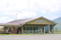
Latest photo of Ashe County Airport (GEV)
Mark Pasqualino
| FAA Information Effective | 2026-09-03 |
| Airport Identifier | GEV |
| Airport Status | Operational |
| Longitude/Latitude |
81°25'6.6000"
W /
36°25'56.9000"
N -81.418500 / 36.432472 (Estimated) |
| Elevation | 3177.50 ft / 968.50 m (Surveyed) |
| Land | 106 acres |
| From nearest city | 3 nautical miles E of Jefferson, NC |
| Location | Ashe County, NC |
| Magnetic Variation | 07W (2000) |
| Airport Use | Open to public |
| Wind indicator | Yes |
| Segmented Circle | Yes |
| Control Tower | NON-ATCT |
| Lighting Schedule | SEE RMK |
| Beacon Color | White-Green (lighted land airport) |
| Landing fee charge | No |
| Sectional chart | CINCINNATI |
| Region | ASO - Southern |
| Responsible ARTCC | ZTL - ATLANTA |
| Tie-in FSS | RDU - RALEIGH |
| FSS on Airport | No |
| FSS Toll Free | 1-800-WX-BRIEF |
| NOTAMs Facility | GEV (NOTAM-d service available) |
Runway 10/28
| Dimensions | 5002 x 75 ft (1525 x 23 m) |
| Surface | ASPH (EXCELLENT) |
| Surface treatment | |
| Edge lights | Medium |
| 10 | 28 | |
|---|---|---|
| Alignment | 89° | 269° |
| Physical elevation | 3177.50 ft | 3086.90 ft |
| Coordinates | 36.432325 / -81.426991 | 36.432593 / -81.409996 |
| Traffic pattern | Left | Left |
| Runway marking | Non-precision instrument , Good Condition | Non-precision instrument , Good Condition |
| ILS type | LOC/DME | |
| VGSI | 2-light PAPI on left | |
| Runway end lights | Yes |
- RISING TRRN ALL QUADS.
- DEER INVOF ARPT.
- RWYS 10 & 28 SAFETY AREAS HAVE 100 FT DROP-OFFS 270 FT FM THR.
- RWY 28 HAS AN UPHILL GRADE.
- OCNL CROPS AND FARMING EQPT ADJ TO RWY.
- RWY 28 HAS 100 FT DROP-OFFS 90 FT LEFT AND RIGHT OF CNTRLN.
- FOR CD CTC ATLANTA ARTCC AT 770-210-7692.
- COLD TEMPERATURE AIRPORT. ALTITUDE CORRECTION REQUIRED AT OR BELOW -16C.