La Junta Municipal Airport (LHX / KLHX) — La Junta, CO
La Junta Municipal Airport (LHX)
LHX
La Junta Municipal Airport (LHX)
La Junta, CO
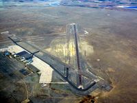
Latest photo of La Junta Municipal Airport (LHX)
Victor Agababov
La Junta Municipal Airport (LHX/KLHX) is a public-use airport located in La Junta, CO. The airport sits at an elevation of 4228 feet above mean sea level. It features 3 runways. Aviation communications are supported by 5 published radio frequencies. The gallery includes 1 photo of operations and aircraft at the airport.
| FAA Information Effective | 2026-09-03 |
| Airport Identifier | LHX |
| Airport Status | Operational |
| Longitude/Latitude |
103°30'35.1000"
W /
38°3'0.0000"
N -103.509750 / 38.050000 (Estimated) |
| Elevation | 4228.60 ft / 1288.88 m (Surveyed) |
| Land | 4200 acres |
| From nearest city | 3 nautical miles N of La Junta, CO |
| Location | Otero County, CO |
| Magnetic Variation | 09E (2005) |
| Airport Use | Open to public |
| Wind indicator | Yes |
| Segmented Circle | Yes |
| Control Tower | NON-ATCT |
| Lighting Schedule | SEE RMK |
| Beacon Color | White-Green (lighted land airport) |
| Landing fee charge | No |
| Sectional chart | WICHITA |
| Region | ANM - Northwest Mountain |
| Responsible ARTCC | ZDV - DENVER |
| Tie-in FSS | DEN - DENVER |
| FSS on Airport | No |
| FSS Toll Free | 1-800-WX-BRIEF |
| NOTAMs Facility | LHX (NOTAM-d service available) |
Runway 08/26
| Dimensions | 6849 x 75 ft (2088 x 23 m) |
| Surface | ASPH (GOOD) |
| Surface treatment | |
| Edge lights | Medium |
| 08 | 26 | |
|---|---|---|
| Alignment | 90° | 270° |
| Physical elevation | 4228.60 ft | 4153.80 ft |
| Coordinates | 38.048139 / -103.523340 | 38.048204 / -103.499562 |
| Traffic pattern | Left | Left |
| Runway marking | Non-precision instrument , Good Condition | Non-precision instrument , Good Condition |
| VGSI | 2-light PAPI on left | 2-light PAPI on left |
| Runway end lights | Yes | Yes |
Runway 12/30
| Dimensions | 5803 x 60 ft (1769 x 18 m) |
| Surface | ASPH-CONC (POOR) |
| Surface treatment |
| 12 | 30 | |
|---|---|---|
| Alignment | 135° | 315° |
| Physical elevation | 4185.70 ft | 4157.90 ft |
| Coordinates | 38.057823 / -103.514857 | 38.046511 / -103.500667 |
| Traffic pattern | Left | Left |
| Runway marking | Basic , Fair Condition | Basic , Fair Condition |
Runway H1
| Dimensions | 145 x 145 ft (44 x 44 m) |
| Surface | ASPH (FAIR) |
| Surface treatment |
| H1 | ||
|---|---|---|
| Physical elevation | 4197.00 ft | ft |
| Coordinates | 38.046219 / -103.514144 | 0.000000 / 0.000000 |
| Traffic pattern | Left | Left |
| Runway marking | Basic , Poor Condition |
- ANTELOPE ON & INVOF ARPT.
- HVY AGRICULTURAL OPNS DURG SUMMER MONTHS.
- RWY 12/30 HAS LOOSE ASPH MTRL IN PRIM SFC WEST SIDE OF RWY FULL LENGTH.
- RWY 12/30 EDGE UNDEFINED.
- BE ALERT; INTENSIVE USAF STUDENT TRNG INVOF COLORADO SPRINGS & PUEBLO COLORADO.
- SELF SERVE JET-A NOT AVAIL.
- FOR CD CTC DENVER ARTCC AT 303-651-4257.