Lawrenceville-vincennes International Airport (LWV)
Lawrenceville-vincennes International Airport (LWV)
LWV
Lawrenceville-vincennes International Airport (LWV)
Lawrenceville, IL
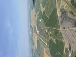
Latest photo of Lawrenceville-vincennes International Airport (LWV)
Jack N. Derrickson
| FAA Information Effective | 2026-09-03 |
| Airport Identifier | LWV |
| Airport Status | Operational |
| Longitude/Latitude |
87°36'19.8000"
W /
38°45'51.4000"
N -87.605500 / 38.764278 (Estimated) |
| Elevation | 429.80 ft / 131.00 m (Surveyed) |
| Land | 3067 acres |
| From nearest city | 3 nautical miles NE of Lawrenceville, IL |
| Location | Lawrence County, IL |
| Magnetic Variation | 01W (1990) |
| Airport Use | Open to public |
| Wind indicator | Yes |
| Control Tower | NON-ATCT |
| Lighting Schedule | SEE RMK |
| Beacon Color | White-Green (lighted land airport) |
| Landing fee charge | No |
| Sectional chart | ST LOUIS |
| Region | AGL - Great Lakes |
| Responsible ARTCC | ZID - INDIANAPOLIS |
| Tie-in FSS | STL - SAINT LOUIS |
| FSS on Airport | No |
| FSS Toll Free | 1-800-WX-BRIEF |
| NOTAMs Facility | LWV (NOTAM-d service available) |
Runway 04U/22U
| Dimensions | 1000 x 200 ft (305 x 61 m) |
| Surface | TURF (FAIR) |
| Surface treatment |
| 04U | 22U | |
|---|---|---|
| Traffic pattern | Left | Right |
Runway 09/27
| Dimensions | 5198 x 100 ft (1584 x 30 m) |
| Surface | ASPH (GOOD) |
| Surface treatment | |
| Edge lights | Medium |
| 09 | 27 | |
|---|---|---|
| Alignment | 89° | 269° |
| Physical elevation | 425.60 ft | 429.50 ft |
| Coordinates | 38.767644 / -87.619089 | 38.767788 / -87.600861 |
| Traffic pattern | Left | Left |
| Runway marking | Non-precision instrument , Good Condition | Non-precision instrument , Good Condition |
| VGSI |
pulsating/steady burning on left *PVASI UNUSBL BYD 8 DEGREES LEFT OF CNTRLN & BYD 6 DEGREES RIGHT OF CNTRLN. |
4-light PAPI on left |
| Approach light | ODALS | |
| Runway end lights | Yes | Yes |
| CL lights | No | No |
| TDZ lights | No | No |
Runway 18/36
| Dimensions | 5199 x 100 ft (1585 x 30 m) |
| Surface | ASPH (GOOD) |
| Surface treatment | |
| Edge lights | Medium |
| 18 | 36 | |
|---|---|---|
| Alignment | 179° | 359° |
| Physical elevation | 429.40 ft | 424.90 ft |
| Coordinates | 38.767990 / -87.601121 | 38.753715 / -87.600957 |
| Traffic pattern | Left | Left |
| Runway marking | Non-precision instrument , Good Condition | Non-precision instrument , Good Condition |
| VGSI |
pulsating/steady burning on left *PVASI UNUSBL BYD 8 DEGREES LEFT OF CNTRLN & BYD 6 DEGREES RIGHT OF CNTRLN. |
4-light PAPI on left |
| Runway end lights | Yes | Yes |
| CL lights | No | No |
| TDZ lights | No | No |
- GLIDER ACTVTY SR-SS. RYS 09/27 & 18/36 HAVE LEFT HAND TFC PATTERN FOR GLIDER ACFT.
- BE ALERT; ODALS FOR RY 27 ARE IN OPERATION SIMULTANEOUSLY WITH REILS ON RY 18.
- FOR CD WHEN RCO 125.6 OTS, CTC EVANSVILLE APCH AT 812-436-4689, WHEN APCH CLSD CTC INDIANAPOLIS ARTCC AT 317-247-2411.
- EXISTED PRIOR TO 1959.