Amata Kabua International Airport (MAJ / PKMJ) — Majuro Atoll
Amata Kabua International Airport (MAJ)
MAJ
Amata Kabua International Airport (MAJ)
Majuro Atoll,
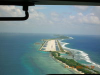
Latest photo of Amata Kabua International Airport (MAJ)
John J. Boling
Amata Kabua International Airport (MAJ/PKMJ) is a public-use airport located in Majuro Atoll. The airport sits at an elevation of 6 feet above mean sea level. It features 1 runway. Aviation communications are supported by 2 published radio frequencies. The gallery includes 1 photo of operations and aircraft at the airport.
| FAA Information Effective | 2026-09-03 |
| Airport Identifier | MAJ |
| Airport Status | Operational |
| Longitude/Latitude |
171°16'19.3020"
E /
7°3'53.9220"
N 171.272028 / 7.064978 (Estimated) |
| Elevation | 6.50 ft / 1.98 m (Surveyed) |
| Land | 135 acres |
| From nearest city | 7 nautical miles SW of Majuro Atoll, |
| Location | Marshall Islands County, MH |
| Magnetic Variation | 10E (1985) |
| Airport Use | Open to public |
| Wind indicator | Yes |
| Segmented Circle | No |
| Control Tower | NON-ATCT |
| Lighting Schedule | SEE RMK |
| Beacon Color | White-Green (lighted land airport) |
| Landing fee charge | No |
| Sectional chart | CAPE LISBURNE |
| Responsible ARTCC | ZAK - OAKLAND OCEANIC ARTCC |
| Tie-in FSS | HNL - HONOLULU |
| FSS on Airport | No |
| FSS Toll Free | 1-800-WX-BRIEF |
| NOTAMs Facility | HNL (NOTAM-d service available) |
Runway 07/25
| Dimensions | 7913 x 150 ft (2412 x 46 m) |
| Surface | ASPH (GOOD) |
| Surface treatment | Saw-cut or plastic Grooved |
| Edge lights | Medium |
| PCN | 64 |
| 07 | 25 | |
|---|---|---|
| Alignment | 76° | 256° |
| Physical elevation | 6.40 ft | 6.30 ft |
| Coordinates | 7.062379 / 171.261428 | 7.067578 / 171.282629 |
| Traffic pattern | Left | Left |
| Runway marking | Precision instrument , Good Condition | Precision instrument , Good Condition |
| VGSI | 4-light PAPI on left | 4-light PAPI on left |
| Runway end lights | Yes | Yes |
| CL lights | No | No |
| TDZ lights | No | No |
- PPR FOR NGT LNDG BY ARPT MGR/DIST ADMIR, EXCP EMERG, RPRT WI 48 HOURS.
- PARTIALLY PAVED WATER CATCHMENT AREA BOTH SIDES OF RWY WITH VENT PIPES 1' ABOVE SFC.
- ARPT SUPERINTENDENT AVAIL SUN-FRI/0800-1700; PHONE 692-247-7612/3113; FAX 692-247-3888.
- (E94) SAWRS
- ARPTS IN TRUST TERRITORY NOT SUBJECT TO FAA REGS. AIRSPACE ANALYSIS NOT REQUIRED.