St Mary's Hospital Heliport (MN33)

MN33
St Mary's Hospital Heliport (MN33)
Duluth, MN
Latest photos of St Mary's Hospital Heliport (MN33)
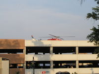
MN33, The Alternate LZ at St. Mary's Duluth (which is the top of a parking ramp)., photo by Mitch Sando
Mitch Sando
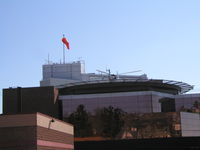
MN33, St. Mary's Medical Center in Downtown Duluth, a Level II Trauma Center., photo by Mitch Sando
Mitch Sando
Location & QuickFacts
FAA Information Effective 2026-07-09
Airport Identifier MN33
Airport Status Operational
Longitude/Latitude 92°5'51.9100" W / 46°47'37.8600" N
-92.097753 / 46.793850 (Estimated)
Elevation 859.60 ft / 262.01 m (Surveyed)
Location St Louis County, MN
Magnetic Variation 01W (2020)
Owner & Manager
Ownership Privately owned
Owner ST MARY'S MEDICAL CENTER
Address 402 E 2ND ST
DULUTH, MN 55805
Phone number 800-447-5540
Manager MICHAEL SULLIVAN
Address 402 E 2ND ST
DULUTH, MN 55805
Phone number 800-447-5540
Airport Operations and Facilities
Airport Use Private
Wind indicator Yes
Segmented Circle No
Control Tower NON-ATCT
Lighting Schedule SEE RMK
Beacon Color White-Green-Yellow (lighted heliport)
Sectional chart GREEN BAY
Region AGL - Great Lakes
Responsible ARTCC ZMP - MINNEAPOLIS
Tie-in FSS PNM - PRINCETON
FSS Toll Free 1-800-WX-BRIEF
NOTAMs Facility FDC
Airport Communications
UNICOM 123.05 MHz
Airport Services
Fuel types A
Runway Information
Runway H2
Dimensions 125 x 125 ft (38 x 38 m)
Surface CONC
Surface treatment
Edge lights FLD
H2
Physical elevation 859.60 ft ft
Coordinates 46.793850 / -92.097753 0.000000 / 0.000000
Traffic pattern Left Left
Runway marking None
Remarks
  • FOR CD CTC MINNEAPOLIS ARTCC AT 651-463-5588.
  • PRVDD APP/DEP 180-360; TFOF/LNDG AREA IS MKD; WIND INDICATOR IS MAINTAINED.