St Luke Hospital Heliport (MN48)
St Luke Hospital Heliport (MN48)
MN48
St Luke Hospital Heliport (MN48)
Duluth, MN
Latest photos of St Luke Hospital Heliport (MN48)

Mitch Sando
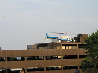
Mitch Sando
| FAA Information Effective | 2026-09-03 |
| Airport Identifier | MN48 |
| Airport Status | Operational |
| Longitude/Latitude |
92°5'14.1100"
W /
46°47'51.9700"
N -92.087253 / 46.797769 (Estimated) |
| Elevation | 902.00 ft / 274.93 m (Estimated) |
| Location | St Louis County, MN |
| Magnetic Variation | 01W (2025) |
| Airport Use | Private |
| Wind indicator | Yes |
| Segmented Circle | No |
| Control Tower | NON-ATCT |
| Lighting Schedule | SEE RMK |
| Sectional chart | GREEN BAY |
| Region | AGL - Great Lakes |
| Responsible ARTCC | ZMP - MINNEAPOLIS |
| Tie-in FSS | PNM - PRINCETON |
| FSS on Airport | No |
| FSS Toll Free | 1-800-WX-BRIEF |
Runway H1
| Dimensions | 42 x 42 ft (13 x 13 m) |
| Surface | CONC |
| Surface treatment | |
| Edge lights | PERI |
| H1 | ||
|---|---|---|
| Physical elevation | 758.00 ft | ft |
| Coordinates | 46.798428 / -92.086639 | 0.000000 / 0.000000 |
| Traffic pattern | Left | Left |
Runway H2
| Dimensions | 55 x 55 ft (17 x 17 m) |
| Surface | ROOF-TOP |
| Surface treatment | |
| Edge lights | PERI |
| H2 | ||
|---|---|---|
| Physical elevation | 902.00 ft | ft |
| Coordinates | 46.797769 / -92.087253 | 0.000000 / 0.000000 |
| Traffic pattern | Left | Left |