Leonard M Thompson International Airport (MYAM) — Marsh Harbour
Leonard M Thompson International Airport (MYAM)
MYAM
Leonard M Thompson International Airport (MYAM)
Marsh Harbour,
Latest photos of Leonard M Thompson International Airport (MYAM)
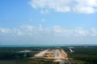
Ms. Rebecca Lewis
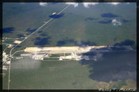
Garey T. Martin
Leonard M Thompson International Airport (MYAM) is a public-use airport located in Marsh Harbour. The airport sits at an elevation of 8 feet above mean sea level. It features 1 runway. Aviation communications are supported by 1 published radio frequency. The gallery includes 2 photos of operations and aircraft at the airport.
| FAA Information Effective | 2026-09-03 |
| Airport Identifier | MYAM |
| Airport Status | Operational |
| Longitude/Latitude |
77°5'6.4200"
W /
26°30'36.4600"
N -77.085117 / 26.510128 (Estimated) |
| Elevation | 8.00 ft / 2.44 m (Estimated) |
| From nearest city | 3 nautical miles SW of Marsh Harbour, |
| Location | Bahamas County, BS |
| Magnetic Variation | 08W (2010) |
Runway 09/27
| Dimensions | 6100 x 100 ft (1859 x 30 m) |
| Surface | ASPH |
| Surface treatment | |
| Edge lights | Medium |
| PCN | 17 |
| 09 | 27 | |
|---|---|---|
| Alignment | 88° | 268° |
| Physical elevation | 8.00 ft | 8.00 ft |
| Coordinates | 26.509889 / -77.094439 | 26.510367 / -77.075797 |
| Traffic pattern | Left | Left |
| Approach light | MALSF | |
| Runway end lights | Yes | Yes |
| TDZ lights | Yes | Yes |