Friedman Meml Airport (SUN / KSUN) — Hailey, ID
Friedman Meml Airport (SUN)
SUN
Friedman Meml Airport (SUN)
Hailey, ID
Latest photo of Friedman Meml Airport (SUN)
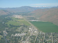
Shale Parker
Friedman Meml Airport (SUN/KSUN) is a public-use airport located in Hailey, ID. The airport sits at an elevation of 5319 feet above mean sea level. It features 1 runway. Aviation communications are supported by 8 published radio frequencies. The gallery includes 1 photo of operations and aircraft at the airport.
| FAA Information Effective | 2026-09-03 |
| Airport Identifier | SUN |
| Airport Status | Operational |
| Longitude/Latitude |
114°17'44.0100"
W /
43°30'13.6130"
N -114.295558 / 43.503781 (Estimated) |
| Elevation | 5319.50 ft / 1621.38 m (Surveyed) |
| Land | 211 acres |
| From nearest city | 1 nautical miles SE of Hailey, ID |
| Location | Blaine County, ID |
| Magnetic Variation | 13E (2020) |
| Airport Use | Open to public |
| Wind indicator | Yes |
| Segmented Circle | No |
| Control Tower | ATCT |
| Lighting Schedule | SEE RMK |
| Beacon Color | White-Green (lighted land airport) |
| Landing fee charge | Yes |
| Sectional chart | SALT LAKE CITY |
| Region | ANM - Northwest Mountain |
| Responsible ARTCC | ZLC - SALT LAKE CITY |
| Tie-in FSS | BOI - BOISE |
| FSS on Airport | No |
| FSS Toll Free | 1-800-WX-BRIEF |
| NOTAMs Facility | SUN (NOTAM-d service available) |
| Certification type/date | 1974/10 |
Runway 13/31
| Dimensions | 7550 x 100 ft (2301 x 30 m) |
| Surface | ASPH (GOOD) |
| Surface treatment | Saw-cut or plastic Grooved |
| Edge lights | High |
| 13 | 31 | |
|---|---|---|
| Alignment | 145° | 325° |
| Physical elevation | 5319.50 ft | 5261.80 ft |
| Coordinates | 43.512240 / -114.303762 | 43.495323 / -114.287357 |
| Traffic pattern | Left | Left |
| Runway marking | Non-precision instrument , Good Condition | Precision instrument , Fair Condition |
| VGSI | 4-light PAPI on left |
- APCH RWY 31 ALG E SIDE OF VALLEY; DEP RWY 13 ALG W SIDE OF VALLEY; WITH LNDG LGT ON; OPDT.
- LOCKED BRAKE TURNS NA.
- SFC COND UNMNT; ARFF UNAVBL 2300-0700.
- ACR LTD PRKG AVBL.
- RWY LTD TO 95000 LB OR LESS MAX TKOF WT. DUAL WHEEL WITH MAX TKOF WT GTR THAN 95000 LB 48 HR PPR - AMGR.
- APU OPS LTD TO 30 MI.
- TWY B5 & B6 RSTD TO WINGSPAN 79 FT OR LESS; DESIGN GROUP II ONLY.
- GA TSNT LESS THAN 40 FT WINGSPAN PRKG ON SECT 2 APN BLUE TIE DOWN SPOTS. TSNT PRKG - 208-788-9511.
- COLD TEMP ARPT. ALT COR RQRD AT OR BLO -13C.
- TSNT HEL OPS - 208-720-5186. ARPT OPS - 208-788-9511 FOR PRKG. DEDICATED HEL PRKG PADS NA.
- FOR CD WHEN ATCT CLSD CTC SALT LAKE ARTCC AT 801-320-2568.
- WHEN ATCT CLSD ARR ANNC ON 125.6 AT 20, 15, 10, 5 MI OUT & SHORT FNA. PAEW ON RWY.
- FUEL SVC AFT DUSK PPR - 208-788-9511.
- PPR FOR WINGSPAN GTR THAN 100 FT.
- ALL SFCS AVBL TO ACRS EXCP B5, B6.
- FLY QUIET VOLUNTARY CURFEW 2300-0700L. DEPART SOUTH. ARRIVE NORTH. CTC AMGR 208-720-5186 FOR NOISE ABATEMENT PROCS.
- HANG GLDRS, PARA GLDRS, & SKYDIVING ON & INVOF ARPT & CLASS D ASP UP TO 18000 FT MSL.
- MTUS TRRN; NIGHT USE & WHEN WX MARGINAL NOT RCMDD. BIRD INVOF RWY.
- ESTABD PRIOR TO 1959.