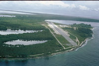
Momote Airport, Manus Island, Papua New Guinea

AYMO/MAS
Momote Airport
Manus Island, Papua New Guinea
Latest photos of Momote Airport, Manus Island, Papua New Guinea
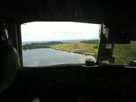
 - Short final RWY16 - by Alan James
Alan James
 - Photographed from TAA DC-3. This field was a former USAAF B-24 base during WWII. - by jdvoss
jdvoss
Location & QuickFacts
Airport Codes
AYMO (ICAO)
MAS (IATA)
Location Manus Island, Papua New Guinea
Airport Type D
Longitude/Latitude
S 02° 03' 42.80" / E 147° 25' 26.94"
-2.061889, 147.424150
Elevation 12 feet (4 meters)
Magnetic Variation E005192 0408
Communications
Type Name Freq 1 Freq 2 Freq 3 Freq 4 Freq 5
Automatic Weather Observing Station AWIS 129.35
Flight Service Station MADANG 120.1 3419K 6622K 8837K
Runway Information
Runway 16/34
Dimensions 6,136 x 148 ft (1870 x 45 m)
Surface Asphalt, asphaltic concrete, tar macadam, or bitumen bound macadam.
PCN 030FAXU
16 34
Heading (Mag/True) 155.0° / 161.0° 335.0° / 341.0°
Latitude S 02° 03' 14.13" S 02° 04' 11.57"
Longitude E 147° 25' 16.97" E 147° 25' 36.95"
Elevation / TDZE 4 ft / U ft 8 ft / U ft
Displaced Threshold 0 ft 197 ft
Slope 0.1° -0.1°
Declared Distances Takeoff: 6136 ft
Landing: 6136 ft
Takeoff: 6136 ft
Landing: 5939 ft
Lighting System 1 Pilot Controlled Lighting Pilot Controlled Lighting
Lighting System 2 Low Intensity Runway Lighting System Low Intensity Runway Lighting System
Lighting System 3 Type 50 Type 50
Remarks
  • [CAUTION]
    Bird haz.
  • [FUEL]
    Avbl 2000-0630 dly. (NC-100LL, A1)
  • [LGT]
    Rwy lgt and PAPI have 30 NM remote ctl by 10 sec pulse on 121.7 for 1 hr lgt.
  • [MISC]
    MET 1700-1100Z.