RAF Kinloss, Kinloss, Moray, United Kingdom

EGQK/FSS
RAF Kinloss
Kinloss, Moray, United Kingdom
Latest photos of RAF Kinloss, Kinloss, Moray, United Kingdom
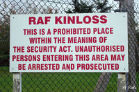
EGQK, A sign at the RAF base at Kinloss. The base was closed as an active airfield in 2012, demoted to emergency diversion status, gaining a Regiment of Royal Engineers in the process who promptly renamed it Kinloss Barracks., photo by Clive Pattle
Clive Pattle
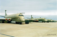
EGQK, Scanned from print. A line-up of Nimrod MR.2's of KMW RAF Kinloss pictured at nearby RAF Lossiemouth EGQS whilst temp detached due to runway repairs at the former, photo by Clive Pattle
Clive Pattle
Location & QuickFacts
Airport Codes
ICAO:EGQKIATA:FSS
Location Kinloss, Moray, United Kingdom
Airport Type Closed
Longitude/Latitude
57.649399, -3.560640
N 57° 38' 57.84" / W 3° 33' 38.30"
Elevation 22 feet (7 meters)
Scheduled Service No
Communications
Type Description Frequency
Approach LOSSIE APP 123.300
Departure LOSSIE DEP 119.350
Ground GND 38.940
Operations OPS 27.897
Tower TWR 122.100
Runway Information
Runway 07/25
Dimensions 7,582 x 151 ft (2311 x 46 m)
Surface Asphalt
Lighted Yes
Status Open
07 25
Heading (True) 71° 251°
Latitude 57.646000
N 57° 38' 45.60"
57.652901
N 57° 39' 10.44"
Longitude -3.578820
W 3° 34' 43.75"
-3.542380
W 3° 32' 32.57"
Elevation 11 ft 22 ft
Displaced Threshold 0 ft 0 ft