Langebaanweg Airport, Langebaanweg, South Africa (FALW / SDB)
Langebaanweg Airport
FALW/SDB
Langebaanweg Airport
Langebaanweg, South Africa
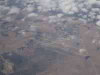
Latest photo of Langebaanweg Airport, Langebaanweg, South Africa
Neil Henry
Langebaanweg Airport (FALW/SDB) is a regional airport located in Langebaanweg, South Africa. The airfield is situated at an elevation of 108 feet (33 meters) above sea level. Operations are conducted on 4 runways. The facility operates 4 published communication frequencies. The gallery features 1 photo documenting air traffic and facilities at the airport.
Runway 02L/20R
| Dimensions | 7,680 x 150 ft (2341 x 46 m) |
| Surface | Asphalt |
| Lighted | Yes |
| Status | Open |
| 02L | 20R | |
| Heading (True) | 1° | 181° |
| Latitude |
-32.979599 S 32° 58' 46.56" |
-32.958500 S 32° 57' 30.60" |
| Longitude |
18.162001 E 18° 09' 43.20" |
18.162500 E 18° 09' 45.00" |
| Elevation | 104 ft | 108 ft |
| Displaced Threshold | 0 ft | 980 ft |
Runway 02R/20L
| Dimensions | 7,689 x 150 ft (2344 x 46 m) |
| Surface | Asphalt |
| Lighted | Yes |
| Status | Open |
| 02R | 20L | |
| Heading (True) | 1° | 181° |
| Latitude |
-32.979698 S 32° 58' 46.91" |
-32.958900 S 32° 57' 32.04" |
| Longitude |
18.166000 E 18° 09' 57.60" |
18.166500 E 18° 09' 59.40" |
| Elevation | 108 ft | 102 ft |
| Displaced Threshold | 0 ft | 0 ft |
Runway 07/25
| Dimensions | 4,935 x 150 ft (1504 x 46 m) |
| Surface | Asphalt |
| Lighted | No |
| Status | Open |
| 07 | 25 | |
| Heading (True) | 46° | 226° |
| Latitude |
-32.968300 S 32° 58' 05.88" |
-32.958900 S 32° 57' 32.04" |
| Longitude |
18.152201 E 18° 09' 07.92" |
18.163799 E 18° 09' 49.68" |
| Elevation | 102 ft | 102 ft |
| Displaced Threshold | 0 ft | 0 ft |
Runway 16/34
| Dimensions | 6,533 x 150 ft (1991 x 46 m) |
| Surface | Asphalt |
| Lighted | Yes |
| Status | Open |
| 16 | 34 | |
| Heading (True) | 136° | 316° |
| Latitude |
-32.965900 S 32° 57' 57.24" |
-32.978901 S 32° 58' 44.04" |
| Longitude |
18.153799 E 18° 09' 13.68" |
18.168501 E 18° 10' 06.60" |
| Elevation | 102 ft | 108 ft |
| Displaced Threshold | 690 ft | 0 ft |