Tangier Ibn Battuta Airport, Tangier, Morocco (GMTT / TNG)
Tangier Ibn Battuta Airport
GMTT/TNG
Tangier Ibn Battuta Airport
Tangier, Morocco
Latest photos of Tangier Ibn Battuta Airport, Tangier, Morocco
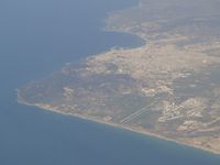
Jean Goubet-FRENCHSKY
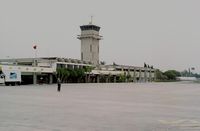
Peter Hamer
Tangier Ibn Battuta Airport (GMTT/TNG) is a major international airport located in Tangier, Morocco. The airfield is situated at an elevation of 62 feet (19 meters) above sea level. Operations are conducted on 2 runways. The facility operates 2 published communication frequencies. The gallery features 2 photos documenting air traffic and facilities at the airport.
Runway 07/25
| Dimensions | 6,562 x 98 ft (2000 x 30 m) |
| Surface | Asphalt |
| Lighted | No |
| Status | Closed |
| 07 | 25 | |
| Heading (True) | 69° | 249° |
| Latitude |
35.719101 N 35° 43' 08.76" |
35.725300 N 35° 43' 31.08" |
| Longitude |
-5.923120 W 5° 55' 23.23" |
-5.902340 W 5° 54' 08.42" |
| Elevation | 0 ft | 0 ft |
| Displaced Threshold | 0 ft | 0 ft |
Runway 10/28
| Dimensions | 11,483 x 148 ft (3500 x 45 m) |
| Surface | Asphalt |
| Lighted | Yes |
| Status | Open |
| 10 | 28 | |
| Heading (True) | 96° | 276° |
| Latitude |
35.733299 N 35° 43' 59.88" |
35.730000 N 35° 43' 48.00" |
| Longitude |
-5.940310 W 5° 56' 25.12" |
-5.901820 W 5° 54' 06.55" |
| Elevation | 20 ft | 62 ft |
| Displaced Threshold | 0 ft | 1640 ft |