Aérodrome de Tarbes Laloubère, Tarbes, France (LFDT)
Aérodrome de Tarbes Laloubère
LFDT
Aérodrome de Tarbes Laloubère
Tarbes, France
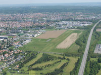
Latest photo of Aérodrome de Tarbes Laloubère, Tarbes, France
Fanste54
Aérodrome de Tarbes Laloubère (LFDT) is a small airfield located in Tarbes, France. The airfield is situated at an elevation of 1076 feet (328 meters) above sea level. Operations are conducted on 1 runway. The gallery features 1 photo documenting air traffic and facilities at the airport.
Runway 08/26
| Dimensions | 2,723 x 0 ft (830 x 0 m) |
| Surface | Unknown |
| Lighted | No |
| Status | Open |
| 08 | 26 | |
| Heading (True) | ° | ° |
| Latitude |
0.000000 N 0° 00' 00.00" |
0.000000 N 0° 00' 00.00" |
| Longitude |
0.000000 E 0° 00' 00.00" |
0.000000 E 0° 00' 00.00" |
| Elevation | 1076 ft | 1076 ft |
| Displaced Threshold | 0 ft | 0 ft |