St. Jean Airport, Gustavia (TFFJ / SBH)
St. Jean Airport
TFFJ/SBH
St. Jean Airport
Gustavia
Latest photos of St. Jean Airport, Gustavia
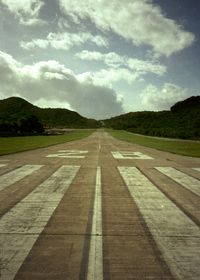
Timothy Aanerud

Timothy Aanerud

Yakfreak - VAP

Yakfreak - VAP
St. Jean Airport (TFFJ/SBH) is a regional airport located in Gustavia. The airfield is situated at an elevation of 49 feet (15 meters) above sea level. Operations are conducted on 1 runway. The facility operates 1 published communication frequency. The gallery features 11 photos documenting air traffic and facilities at the airport.
Runway 10/28
| Dimensions | 2,119 x 59 ft (646 x 18 m) |
| Surface | Concrete |
| Lighted | No |
| Status | Open |
| 10 | 28 | |
| Heading (True) | 89° | 269° |
| Latitude |
17.904322 N 17° 54' 15.56" |
17.904465 N 17° 54' 16.07" |
| Longitude |
-62.846607 W 62° 50' 47.79" |
-62.840508 W 62° 50' 25.83" |
| Elevation | 48 ft | 4 ft |
| Displaced Threshold | 0 ft | 0 ft |