Temora Airport, Temora, Australia (YTEM / TEM)
Temora Airport
YTEM/TEM
Temora Airport
Temora, Australia
Latest photos of Temora Airport, Temora, Australia
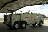
Henk van Capelle
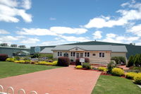
Henk van Capelle
Temora Airport (YTEM/TEM) is a regional airport located in Temora, Australia. The airfield is situated at an elevation of 921 feet (281 meters) above sea level. Operations are conducted on 3 runways. The facility operates 2 published communication frequencies. The gallery features 2 photos documenting air traffic and facilities at the airport.
Runway 05/23
| Dimensions | 6,454 x 98 ft (1967 x 30 m) |
| Surface | Paved |
| Lighted | Yes |
| Status | Open |
| 05 | 23 | |
| Heading (True) | 62° | 242° |
| Latitude |
-34.425800 S 34° 25' 32.88" |
-34.417500 S 34° 25' 03.00" |
| Longitude |
147.494995 E 147° 29' 41.98" |
147.514008 E 147° 30' 50.43" |
| Elevation | 913 ft | 902 ft |
| Displaced Threshold | 0 ft | 0 ft |
Runway 09/27
| Dimensions | 2,674 x 98 ft (815 x 30 m) |
| Surface | Gravel |
| Lighted | No |
| Status | Open |
| 09 | 27 | |
| Heading (True) | 99° | 279° |
| Latitude |
-34.421799 S 34° 25' 18.48" |
-34.423000 S 34° 25' 22.80" |
| Longitude |
147.507996 E 147° 30' 28.79" |
147.516998 E 147° 31' 01.19" |
| Elevation | 910 ft | 910 ft |
| Displaced Threshold | 0 ft | 0 ft |
Runway 18/36
| Dimensions | 4,816 x 98 ft (1468 x 30 m) |
| Surface | Asphalt |
| Lighted | Yes |
| Status | Open |
| 18 | 36 | |
| Heading (True) | 189° | 9° |
| Latitude |
-34.417400 S 34° 25' 02.64" |
-34.430500 S 34° 25' 49.80" |
| Longitude |
147.514999 E 147° 30' 54.00" |
147.513000 E 147° 30' 46.80" |
| Elevation | 905 ft | 915 ft |
| Displaced Threshold | 0 ft | 0 ft |