Aircraft N479AZ Data
1
aircraft record found
N479AZ
1993 Boeing 767-323/ER(BDSF), c/n 25450 l/n 495
Latest photos of N479AZ
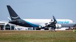
AviationLover50
@ KLAL
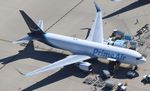
Mark Pasqualino
@ KRFD

Mark Pasqualino
@ KRFD
Recent Routes
NO LIVE DATA
Air Transport International
| Time | Callsign | FL | Speed | Heading | Route |
|---|---|---|---|---|---|
| 2026-10-21 05:12 UTC | ATN3307 / 8C3307 | — | 0 kt | 183° | — |
| 2026-10-21 02:32 UTC | ATN3371 / 8C3371 | FL21 | 136 kt | 35° | — |
| 2026-10-20 17:26 UTC | ATN9983 / 8C9983 | FL11 | 141 kt | 270° | — |
| 2026-10-20 08:44 UTC | ATN3383 / 8C3383 | FL1 | 137 kt | 53° | — |
| 2026-10-20 01:16 UTC | ATN6775 / 8C6775 | FL12 | 123 kt | 270° | — |
| 2026-10-19 21:54 UTC | ATN3363 / 8C3363 | — | 0 kt | 17° |
DEN → SBD
DEN
→
SBD
Denver International Airport → San Bernardino International Airport |
| 2026-10-19 17:34 UTC | ATN3340 / 8C3340 | — | 0 kt | 180° | — |
| 2026-10-19 07:20 UTC | ATN3378 / 8C3378 | FL-1 | 131 kt | 90° | — |
| 2026-10-18 23:10 UTC | ATN3326 / 8C3326 | FL5 | 148 kt | 181° |
BWI → CVG
BWI
→
CVG
Baltimore/washington International Thurgood Marshall Airport → Cincinnati/northern Kentucky International Airport |
| 2026-10-18 11:54 UTC | ATN3361 / 8C3361 | — | 2 kt | 276° | — |
| 2026-10-18 03:26 UTC | ATN3309 / 8C3309 | FL0 | 155 kt | 271° | — |
| 2026-10-17 22:06 UTC | ATN3352 / 8C3352 | — | 18 kt | 273° |
ATL → BWI
ATL
→
BWI
Hartsfield/jackson Atlanta International Airport → Baltimore/washington International Thurgood Marshall Airport |
| 2026-10-17 17:20 UTC | ATN3320 / 8C3320 | — | 0 kt | 90° |
BWI → ATL
BWI
→
ATL
Baltimore/washington International Thurgood Marshall Airport → Hartsfield/jackson Atlanta International Airport |
| 2026-10-17 13:08 UTC | ATN3387 / 8C3387 | FL0 | 151 kt | 324° |
SBD → BWI
SBD
→
BWI
San Bernardino International Airport → Baltimore/washington International Thurgood Marshall Airport |
| 2026-10-17 04:26 UTC | ATN3399 / 8C3399 | — | 1 kt | 346° |
SEA → SBD
SEA
→
SBD
Seattle-tacoma International Airport → San Bernardino International Airport |
| 2026-10-16 21:14 UTC | ATN3379 / 8C3379 | — | 3 kt | 3° |
KANC → SEA
KANC
→
SEA
Ted Stevens Anchorage International Airport → Seattle-tacoma International Airport |
| 2026-10-16 15:38 UTC | ATN3316 / 8C3316 | — | 0 kt | 90° |
SEA → LHD
SEA
→
LHD
Seattle-tacoma International Airport → Lake Hood Seaplane Base Airport |
| 2026-10-16 06:56 UTC | ATN3395 / 8C3395 | — | 0 kt | 0° |
DEN → SEA
DEN
→
SEA
Denver International Airport → Seattle-tacoma International Airport |
| 2026-10-16 02:14 UTC | ATN3397 / 8C3397 | — | 0 kt | 180° |
SEA → DEN
SEA
→
DEN
Seattle-tacoma International Airport → Denver International Airport |
| 2026-10-15 08:58 UTC | ATN3337 / 8C3337 | — | 2 kt | 180° |
SBD → SEA
SBD
→
SEA
San Bernardino International Airport → Seattle-tacoma International Airport |
| 2026-10-13 18:34 UTC | ATN9703 / 8C9703 | — | 1 kt | 90° |
KANC → SEA
KANC
→
SEA
Ted Stevens Anchorage International Airport → Seattle-tacoma International Airport |
| 2026-10-13 13:34 UTC | ATN3351 / 8C3351 | — | 0 kt | 90° |
SEA → LHD
SEA
→
LHD
Seattle-tacoma International Airport → Lake Hood Seaplane Base Airport |
| 2026-10-11 07:10 UTC | ATN3302 / 8C3302 | FL4 | 144 kt | 271° | — |
| 2026-10-10 20:48 UTC | ATN3315 / 8C3315 | FL11 | 147 kt | 217° | — |
| 2026-10-10 11:14 UTC | ATN3348 / 8C3348 | — | 1 kt | 259° |
ATL → AFW
ATL
→
AFW
Hartsfield/jackson Atlanta International Airport → Perot Fld/fort Worth Alliance Airport |
| 2026-10-10 06:10 UTC | ATN3331 / 8C3331 | — | 3 kt | 90° | — |
| 2026-10-09 22:36 UTC | ATN3332 / 8C3332 | FL10 | 141 kt | 217° | — |
| 2026-10-09 19:26 UTC | ATN6735 / 8C6735 | FL44 | 270 kt | 355° | — |
| 2026-10-09 13:26 UTC | ATN3314 / 8C3314 | FL4 | 137 kt | 90° | — |
| 2026-10-09 05:36 UTC | ATN3350 / 8C3350 | FL10 | 157 kt | 327° | — |
| 2026-10-09 00:10 UTC | ATN3385 / 8C3385 | FL12 | 158 kt | 217° | — |
| 2026-10-08 20:28 UTC | ATN3376 / 8C3376 | FL4 | 123 kt | 224° | — |
| 2026-10-08 02:54 UTC | ATN3306 / 8C3306 | FL24 | 168 kt | 185° | — |
| 2026-10-07 20:22 UTC | ATN3327 / 8C3327 | FL1 | 143 kt | 211° | — |
| 2026-10-07 07:42 UTC | ATN3312 / 8C3312 | — | 8 kt | 180° | — |
| 2026-10-07 04:12 UTC | ATN3341 / 8C3341 | FL3 | 144 kt | 224° | — |
| 2026-10-06 21:30 UTC | ATN3386 / 8C3386 | FL10 | 155 kt | 90° | — |
| 2026-10-06 04:14 UTC | ATN3356 / 8C3356 | — | 1 kt | 141° | — |
| 2026-10-05 21:30 UTC | ATN3394 / 8C3394 | FL13 | 147 kt | 38° | — |
| 2026-10-05 15:38 UTC | ATN6703 / 8C6703 | — | 1 kt | 270° | — |
| 2026-10-05 06:52 UTC | ATN3364 / 8C3364 | — | 5 kt | 0° | — |
| 2026-10-04 23:46 UTC | ATN3324 / 8C3324 | FL22 | 215 kt | 193° | — |
| 2026-10-04 20:08 UTC | ATN3357 / 8C3357 | — | 3 kt | 141° | — |
| 2026-10-04 11:52 UTC | ATN3359 / 8C3359 | — | 17 kt | 11° |
JFK → CVG
JFK
→
CVG
John F Kennedy International Airport → Cincinnati/northern Kentucky International Airport |
| 2026-10-04 06:14 UTC | ATN3345 / 8C3345 | — | 14 kt | 301° | — |
| 2026-10-03 19:06 UTC | ATN3323 / 8C3323 | FL12 | 150 kt | 37° | — |
| 2026-10-03 08:52 UTC | ATN3330 / 8C3330 | — | 8 kt | 48° | — |
| 2026-09-29 08:28 UTC | ATN3367 / 8C3367 | — | 1 kt | 270° |
SMF → PHX
SMF
→
PHX
Sacramento International Airport → Phoenix Sky Harbor International Airport |
| 2026-09-29 02:44 UTC | ATN3318 / 8C3318 | — | 0 kt | 90° |
KAZ3 → SMF
KAZ3 →
SMF
KAZ3 → Sacramento International Airport |
| 2026-09-28 22:46 UTC | ATN3398 / 8C3398 | — | 3 kt | 270° | — |
| 2026-09-28 12:46 UTC | ATN3311 / 8C3311 | — | 13 kt | 180° |
DEN → CVG
DEN
→
CVG
Denver International Airport → Cincinnati/northern Kentucky International Airport |
| 2026-09-28 07:28 UTC | ATN3321 / 8C3321 | — | 18 kt | 270° | — |
| 2026-09-27 20:30 UTC | ATN3343 / 8C3343 | FL14 | 153 kt | 37° | — |
| 2026-09-27 14:04 UTC | ATN3388 / 8C3388 | FL5 | 159 kt | 270° | — |
Live location data from OpenSky Network
Airframe Info
| Manufacturer | Boeing |
| Model | 767-323/ER(BDSF) Search all Boeing 767-323/ER(BDSF) |
| Year built | 1993 |
| Construction Number (C/N) | 25450 |
| Line Number (L/N) | 495 |
| Aircraft Type | Fixed wing multi engine |
| Number of Engines | 2 |
| Engine Type | Turbofan |
| Engine Manufacturer and Model | GE CF6-80C2B6 |
| Also Registered As |
|
Aircraft
| Registration Number | N479AZ |
| Mode S (ICAO24) Code | a5e2a1 |
| Certification Class | Standard |
| Certification Issued | 2019-05-14 |
| Air Worthiness Test | 1993-05-23 |
| Last Action Taken | 2023-08-04 |
| Current Status | Valid |
| Delivery Date | 1993-05-27 |
Owner
| Registration Type | Corporation |
| Owner | CARGO AIRCRAFT MANAGEMENT INC |
| Address |
Wilmington, OH 451779550 United States |
| Region | Great Lakes |