N568NN — 2015 Bombardier CRJ-900 (CL-600-2D24) Data
1
aircraft record found
N568NN
2015 Bombardier CRJ-900 (CL-600-2D24), c/n 15355
N568NN is a 2015 Bombardier CRJ-900 (CL-600-2D24) (serial number 15355). It is powered by 2 engines. Registration status is listed as Valid, with ownership recorded under AMERICAN AIRLINES INC in Fort Worth, TX, United States. The profile includes 2 photos documenting this aircraft.
Latest photos of N568NN
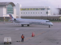
Christian Maurer
@ CVG
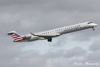
Donten Photography
@ KSRQ
Recent Routes
NO LIVE DATA
PSA Airlines
| Time | Callsign | FL | Speed | Heading | Route |
|---|---|---|---|---|---|
| 2026-10-30 04:38 UTC | JIA5633 | FL14 | 154 kt | 339° | — |
| 2026-10-30 01:16 UTC | JIA5091 | — | 84 kt | 352° | — |
| 2026-10-29 18:50 UTC | JIA5370 | FL8 | 141 kt | 356° | — |
| 2026-10-29 14:30 UTC | JIA5101 | — | 78 kt | 352° |
IAD → CLT
IAD
→
CLT
Washington Dulles International Airport → Charlotte/douglas International Airport |
| 2026-10-29 12:42 UTC | JIA5490 | — | 15 kt | 87° | — |
| 2026-10-28 14:00 UTC | JIA9956 | — | 13 kt | 65° | — |
| 2026-10-27 15:58 UTC | JIA5581 | FL-1 | 133 kt | 43° | — |
| 2026-10-27 13:00 UTC | JIA5325 | — | 27 kt | 208° | — |
| 2026-10-27 03:02 UTC | JIA5361 | FL4 | 123 kt | 0° | — |
| 2026-10-26 23:00 UTC | JIA0568 | — | 7 kt | 276° | — |
| 2026-10-26 18:20 UTC | JIA5258 | — | 8 kt | 290° | — |
| 2026-10-26 11:20 UTC | JIA5469 | — | 6 kt | 309° | — |
| 2026-10-26 04:54 UTC | JIA5434 | FL42 | 113 kt | 175° | — |
| 2026-10-26 02:26 UTC | JIA5471 | — | 5 kt | 323° | — |
| 2026-10-25 20:28 UTC | JIA5437 | — | 15 kt | 267° | — |
| 2026-10-25 13:36 UTC | JIA5556 | — | 8 kt | 278° |
ROA → DFW
ROA
→
DFW
Roanoke/blacksburg Regional (woodrum Fld) Airport → Dallas-fort Worth International Airport |
| 2026-10-25 02:44 UTC | JIA5559 | — | 14 kt | 138° |
DFW → ROA
DFW
→
ROA
Dallas-fort Worth International Airport → Roanoke/blacksburg Regional (woodrum Fld) Airport |
| 2026-10-24 22:42 UTC | JIA5052 | — | 24 kt | 264° | — |
| 2026-10-23 23:48 UTC | JIA5402 | — | 15 kt | 307° | — |
| 2026-10-23 19:06 UTC | JIA5643 | — | 10 kt | 267° | — |
| 2026-10-23 12:20 UTC | JIA5104 | — | 1 kt | 318° | — |
| 2026-10-23 02:40 UTC | JIA5086 | FL14 | 130 kt | 200° | — |
| 2026-10-23 00:06 UTC | JIA5228 | — | 8 kt | 301° | — |
| 2026-10-22 20:50 UTC | JIA5564 | FL9 | 144 kt | 218° | — |
| 2026-10-22 17:12 UTC | JIA5170 | FL17 | 145 kt | 356° | — |
| 2026-10-22 14:58 UTC | JIA5623 | FL6 | 133 kt | 230° | — |
| 2026-10-22 12:42 UTC | JIA5310 | — | 6 kt | 217° | — |
| 2026-10-22 04:04 UTC | JIA5493 | FL6 | 131 kt | 262° | — |
| 2026-10-22 01:10 UTC | JIA5367 | — | 6 kt | 194° | — |
| 2026-10-21 19:40 UTC | JIA5356 | — | 12 kt | 259° | — |
| 2026-10-21 16:40 UTC | JIA5474 | FL5 | 126 kt | 252° | — |
| 2026-10-21 13:36 UTC | JIA5570 | — | 0 kt | 169° | — |
| 2026-10-20 23:52 UTC | JIA5237 | FL4 | 139 kt | 90° | — |
| 2026-10-20 20:44 UTC | JIA5350 | FL9 | 98 kt | 356° |
YUL → CLT
YUL
→
CLT
Montreal / Pierre Elliott Trudeau International Airport → Charlotte/douglas International Airport |
| 2026-10-20 13:10 UTC | JIA5242 | FL5 | 127 kt | 357° | — |
| 2026-10-20 08:34 UTC | MTX568 | — | 10 kt | 231° | — |
| 2026-10-20 00:36 UTC | JIA5435 | FL7 | 137 kt | 236° | — |
| 2026-10-19 22:18 UTC | JIA5018 | FL6 | 126 kt | 357° |
IAD → CLT
IAD
→
CLT
Washington Dulles International Airport → Charlotte/douglas International Airport |
| 2026-10-19 17:52 UTC | JIA5096 | FL5 | 129 kt | 357° | — |
| 2026-10-19 15:50 UTC | JIA5103 | FL5 | 141 kt | 274° | — |
| 2026-10-19 13:26 UTC | JIA5403 | FL3 | 132 kt | 355° | — |
| 2026-10-19 00:44 UTC | JIA5016 | FL0 | 129 kt | 151° | — |
| 2026-10-18 21:18 UTC | JIA5130 | FL7 | 87 kt | 355° | — |
| 2026-10-18 17:16 UTC | JIA5145 | FL4 | 129 kt | 356° | — |
| 2026-10-18 10:28 UTC | JIA5264 | FL6 | 122 kt | 355° | — |
| 2026-10-18 03:50 UTC | JIA5263 | FL9 | 144 kt | 227° | — |
| 2026-10-18 01:24 UTC | JIA5538 | FL5 | 104 kt | 356° | — |
| 2026-10-17 04:52 UTC | JIA5045 | — | 204 kt | 146° |
YYZ → CLT
YYZ
→
CLT
Lester B Pearson International Airport → Charlotte/douglas International Airport |
| 2026-10-16 19:16 UTC | JIA5143 | FL9 | 135 kt | 176° | — |
| 2026-10-16 16:04 UTC | JIA5651 | FL7 | 140 kt | 176° | — |
| 2026-10-16 12:54 UTC | JIA5540 | FL7 | 135 kt | 176° | — |
| 2026-10-16 04:08 UTC | JIA5464 | FL39 | 296 kt | 39° | — |
| 2026-10-16 01:24 UTC | JIA5182 | FL7 | 135 kt | 175° | — |
| 2026-10-15 22:36 UTC | JIA5397 | FL3 | 137 kt | 336° | — |
| 2026-10-15 18:52 UTC | JIA5575 | FL6 | 142 kt | 176° | — |
| 2026-10-15 11:54 UTC | JIA5049 | FL7 | 142 kt | 356° | — |
| 2026-10-15 01:26 UTC | JIA5273 | FL2 | 141 kt | 91° | — |
| 2026-10-14 22:22 UTC | JIA5441 | — | 6 kt | 293° |
BGR → PHL
BGR
→
PHL
Bangor International Airport → Philadelphia International Airport |
| 2026-10-14 20:08 UTC | JIA5492 | — | 0 kt | 343° | — |
| 2026-10-14 11:44 UTC | JIA5368 | — | 12 kt | 293° |
BGR → PHL
BGR
→
PHL
Bangor International Airport → Philadelphia International Airport |
| 2026-10-14 03:40 UTC | JIA5120 | — | 0 kt | 346° |
PHL → BGR
PHL
→
BGR
Philadelphia International Airport → Bangor International Airport |
| 2026-10-14 01:04 UTC | JIA5129 | — | 10 kt | 295° | — |
| 2026-10-13 20:32 UTC | JIA5040 | — | 0 kt | 172° | — |
| 2026-10-13 13:56 UTC | JIA5192 | — | 10 kt | 335° |
YYZ → PHL
YYZ
→
PHL
Lester B Pearson International Airport → Philadelphia International Airport |
| 2026-10-13 01:22 UTC | JIA5191 | FL7 | 0 kt | 110° |
PHL → YYZ
PHL
→
YYZ
Philadelphia International Airport → Lester B Pearson International Airport |
| 2026-10-12 22:02 UTC | JIA5127 | — | 7 kt | 276° | — |
| 2026-10-12 17:32 UTC | JIA5215 | — | 8 kt | 264° | — |
| 2026-10-12 14:48 UTC | JIA5593 | FL10 | 143 kt | 225° | — |
| 2026-10-12 11:50 UTC | JIA5355 | FL5 | 130 kt | 180° | — |
| 2026-10-12 04:44 UTC | JIA5312 | FL12 | 152 kt | 144° | — |
| 2026-10-12 02:10 UTC | JIA5164 | — | 11 kt | 264° | — |
| 2026-10-11 21:12 UTC | JIA5639 | FL8 | 134 kt | 176° | — |
| 2026-10-11 18:52 UTC | JIA5365 | FL11 | 133 kt | 0° | — |
| 2026-10-11 15:56 UTC | JIA5196 | — | 8 kt | 284° | — |
| 2026-10-11 11:04 UTC | JIA5487 | — | 10 kt | 287° | — |
| 2026-10-11 03:16 UTC | JIA5259 | — | 14 kt | 222° |
PHL → BDL
PHL
→
BDL
Philadelphia International Airport → Bradley International Airport |
| 2026-10-11 01:02 UTC | JIA5531 | — | 8 kt | 284° | — |
| 2026-10-10 22:12 UTC | JIA5439 | — | 2 kt | 62° | — |
| 2026-10-10 18:48 UTC | JIA5240 | — | 0 kt | 214° | — |
| 2026-10-09 11:44 UTC | JIA5620 | — | 6 kt | 278° | — |
| 2026-10-05 23:48 UTC | JIA5352 | FL13 | 126 kt | 44° | — |
| 2026-10-05 21:08 UTC | JIA531Q | FL-1 | 118 kt | 255° | — |
| 2026-10-05 11:30 UTC | JIA5362 | — | 0 kt | 174° | — |
| 2026-10-05 04:28 UTC | JIA5595 | FL2 | 122 kt | 322° | — |
| 2026-10-05 02:22 UTC | JIA5189 | — | 8 kt | 287° | — |
| 2026-10-04 23:46 UTC | JIA5636 | FL2 | 137 kt | 141° | — |
| 2026-10-04 21:42 UTC | JIA5543 | — | 10 kt | 284° | — |
| 2026-10-04 12:54 UTC | JIA5318 | — | 15 kt | 290° |
MSN → PHL
MSN
→
PHL
Dane County Rgnl/truax Fld Airport → Philadelphia International Airport |
| 2026-10-04 02:42 UTC | JIA5512 | FL8 | 113 kt | 209° | — |
| 2026-10-03 22:12 UTC | JIA5334 | — | 12 kt | 287° | — |
| 2026-10-03 19:34 UTC | JIA5227 | FL6 | 122 kt | 208° | — |
| 2026-10-03 00:08 UTC | JIA5287 | — | 6 kt | 287° | — |
| 2026-10-02 19:44 UTC | JIA5102 | — | 16 kt | 250° | — |
| 2026-10-02 13:44 UTC | JIA5578 | — | 12 kt | 14° | — |
| 2026-10-01 23:38 UTC | JIA5337 | FL10 | 132 kt | 180° | — |
| 2026-10-01 20:30 UTC | JIA5479 | — | 12 kt | 14° | — |
| 2026-10-01 17:20 UTC | JIA5478 | FL10 | 142 kt | 54° | — |
| 2026-09-30 22:50 UTC | JIA5563 | FL4 | 131 kt | 90° | — |
| 2026-09-30 19:46 UTC | JIA5156 | FL15 | 163 kt | 355° |
ABE → CLT
ABE
→
CLT
Lehigh Valley International Airport → Charlotte/douglas International Airport |
| 2026-09-30 12:48 UTC | JIA5214 | FL13 | 149 kt | 356° | — |
Live location data from OpenSky Network
Airframe Info
| Manufacturer | Bombardier |
| Model | CRJ-900 (CL-600-2D24) Search all Bombardier CRJ-900 (CL-600-2D24) |
| Year built | 2015 |
| Construction Number (C/N) | 15355 |
| Aircraft Type | Fixed wing multi engine |
| Number of Engines | 2 |
| Engine Type | Turbofan |
| Engine Manufacturer and Model | GE CF34-8C5 |
Aircraft
| Registration Number | N568NN |
| Mode S (ICAO24) Code | a745db |
| Certification Class | Standard |
| Certification Issued | 2015-02-25 |
| Air Worthiness Test | 2015-02-25 |
| Last Action Taken | 2023-04-21 |
| Current Status | Valid |
Owner
| Registration Type | Corporation |
| Owner | AMERICAN AIRLINES INC |
| Address |
Md 8b369 Fort Worth, TX 76155 United States |
| Region | Southwestern |