Cross Keys Airport (17N)
Cross Keys Airport (17N)
17N
Cross Keys Airport (17N)
Cross Keys, NJ
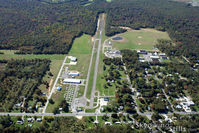
Latest photo of Cross Keys Airport (17N)
Dave G
| FAA Information Effective | 2026-07-09 |
| Airport Identifier | 17N |
| Airport Status | Operational |
| Longitude/Latitude |
75°1'58.8110"
W /
39°42'19.7130"
N -75.033003 / 39.705476 (Estimated) |
| Elevation | 162.00 ft / 49.38 m (Estimated) |
| Land | 280 acres |
| From nearest city | 1 nautical miles S of Cross Keys, NJ |
| Location | Gloucester County, NJ |
| Magnetic Variation | 10W (1980) |
| Airport Use | Open to public |
| Wind indicator | Yes |
| Segmented Circle | No |
| Control Tower | NON-ATCT |
| Lighting Schedule | SS-SR |
| Beacon Color | White-Green (lighted land airport) |
| Landing fee charge | No |
| Sectional chart | WASHINGTON |
| Region | AEA - Eastern |
| Traffic Pattern Alt | 838 ft |
| Responsible ARTCC | ZNY - NEW YORK |
| Tie-in FSS | MIV - MILLVILLE |
| FSS on Airport | No |
| FSS Toll Free | 1-800-WX-BRIEF |
| NOTAMs Facility | MIV (NOTAM-d service available) |
Runway 09/27
| Dimensions | 3500 x 50 ft (1067 x 15 m) |
| Surface | ASPH (GOOD) |
| Surface treatment | |
| Edge lights | Non-standard lighting system |
| 09 | 27 | |
|---|---|---|
| Alignment | 74° | 254° |
| Physical elevation | 137.00 ft | 161.00 ft |
| Coordinates | 39.704152 / -75.038976 | 39.706806 / -75.027020 |
| Traffic pattern | Right | Left |
| Runway marking | Non-precision instrument , Fair Condition | Basic , Fair Condition |
| Runway end lights | No | No |
| CL lights | No | No |
| TDZ lights | No | No |