Oak Tree Landing Airport (6J8) — High Springs, FL
Oak Tree Landing Airport (6J8)
6J8
Oak Tree Landing Airport (6J8)
High Springs, FL
Latest photos of Oak Tree Landing Airport (6J8)
Bob Simmermon
Bob Simmermon
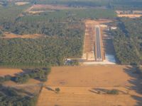
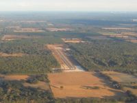
Oak Tree Landing Airport (6J8) is a public-use airport located in High Springs, FL. The airport sits at an elevation of 90 feet above mean sea level. It features 1 runway. Aviation communications are supported by 1 published radio frequency. The gallery includes 2 photos of operations and aircraft at the airport.
| FAA Information Effective | 2026-09-03 |
| Airport Identifier | 6J8 |
| Airport Status | Operational |
| Longitude/Latitude |
82°39'54.7500"
W /
29°43'12.9500"
N -82.665208 / 29.720264 (Estimated) |
| Elevation | 90.00 ft / 27.43 m (Estimated) |
| Land | 1300 acres |
| From nearest city | 7 nautical miles SW of High Springs, FL |
| Location | Alachua County, FL |
| Magnetic Variation | 02W (1985) |
| Airport Use | Open to public |
| Wind indicator | Yes |
| Segmented Circle | No |
| Control Tower | NON-ATCT |
| Landing fee charge | Yes |
| Sectional chart | JACKSONVILLE |
| Region | ASO - Southern |
| Responsible ARTCC | ZJX - JACKSONVILLE |
| Tie-in FSS | GNV - GAINESVILLE |
| FSS on Airport | No |
| FSS Toll Free | 1-800-WX-BRIEF |
| NOTAMs Facility | GNV (NOTAM-d service available) |
Runway 09/27
| Dimensions | 4630 x 75 ft (1411 x 23 m) |
| Surface | ASPH (GOOD) |
| Surface treatment |
| 09 | 27 | |
|---|---|---|
| Physical elevation | 90.00 ft | 90.00 ft |
| Coordinates | 29.720194 / -82.672500 | 29.720333 / -82.657917 |
| Traffic pattern | Left | Left |
| Runway marking | Non-precision instrument , Poor Condition | Non-precision instrument , Poor Condition |
- 280 FT TWR 2 NM NW OF ARPT.
- FOR CD CTC JACKSONVILLE APCH AT 904-741-0284.
- MEN & EQPT WORKING INVOF THE RWY.
- AUDIO AND VIDEO RECORDING ON PREMISES
- AGRICULTURAL BURNING IN AREA.
- 250.00 LNDG FEE RQD TO INGRESS/EGRESS PVT PROPERTY. 24 HR ADVN NOTIFICATION RQSTD. CTC 386-454-1511, ANY EXT.
- VFR OPERATIONS.