Lucas Fld Airport (79KY)
Lucas Fld Airport (79KY)
79KY
Lucas Fld Airport (79KY)
Nicholasville, KY
Latest photo of Lucas Fld Airport (79KY)
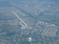
Bob Simmermon
| FAA Information Effective | 2026-09-03 |
| Airport Identifier | 79KY |
| Airport Status | Operational |
| Longitude/Latitude |
84°36'37.9000"
W /
37°52'16.6000"
N -84.610528 / 37.871278 (Estimated) |
| Elevation | 905.80 ft / 276.09 m (Surveyed) |
| Land | 257 acres |
| From nearest city | 1 nautical miles W of Nicholasville, KY |
| Location | Jessamine County, KY |
| Magnetic Variation | 05W (2005) |
Runway 09/27
| Dimensions | 5488 x 100 ft (1673 x 30 m) |
| Surface | CONC |
| Surface treatment | |
| Edge lights | High |
| 09 | 27 | |
|---|---|---|
| Physical elevation | 905.20 ft | 897.80 ft |
| Coordinates | 37.871749 / -84.620027 | 37.870815 / -84.601052 |
| Traffic pattern | Left | Left |
| Runway marking | Non-precision instrument , Fair Condition | Non-precision instrument , Fair Condition |
| VGSI | 4-light PAPI on left | 4-light PAPI on left |
| Runway end lights | Yes | Yes |