Franklin County Airport (F53)
Franklin County Airport (F53)
F53
Franklin County Airport (F53)
Mount Vernon, TX
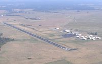
Latest photo of Franklin County Airport (F53)
Mark McEnturff
| FAA Information Effective | 2013-12-12 |
| Airport Identifier | F53 |
| Airport Status | Operational |
| Longitude/Latitude |
095-14-14.0000W/33-12-55.2000N -95.237222/33.215333 (Estimated) |
| Elevation | 412 ft / 125.58 m (Surveyed) |
| Land | 159 acres |
| From nearest city | 2 nautical miles NW of Mount Vernon, TX |
| Location | Franklin County, TX |
| Magnetic Variation | 06E (1985) |
| Airport Use | Open to public |
| Wind indicator | Yes |
| Segmented Circle | Yes |
| Control Tower | No |
| Lighting Schedule | SS-SR |
| Beacon Color | Clear-Green (lighted land airport) |
| Sectional chart | Dallas-ft Worth |
| Region | ASW - Southwest |
| Boundary ARTCC | ZFW - Fort Worth |
| Tie-in FSS | FTW - Fort Worth |
| FSS Phone | 817-541-3474 |
| FSS Toll Free | 1-800-WX-BRIEF |
| NOTAMs Facility | FTW (NOTAM-d service available) |
| Federal Agreements | NGY |
Runway 13/31
| Dimensions | 3900 x 60 ft (1189 x 18 m) |
| Surface | ASPH-G |
| 13 | 31 | |
|---|---|---|
| Alignment | 127° | 127° |
| Physical elevation | 396.00 ft | 412.00 ft |
| Coordinates | 33.219211N / 95.241615W | 33.211440N / 95.232833W |
| Traffic pattern | Left | Left |
| Runway marking | Non-precision instrument , Fair Condition | Non-precision instrument , Fair Condition |
| VGSI | 2-light PAPI on left | 2-light PAPI on left |