Wild Basin Heliport (TX95)

TX95
Wild Basin Heliport (TX95)
Austin, TX
Latest photo of Wild Basin Heliport (TX95)
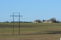
TX95, Coppinger Farm Airfield...I think...it was hard to discern this airport from the ground..., photo by Zane Adams
Zane Adams
Location & QuickFacts
FAA Information Effective 2026-07-09
Airport Identifier TX95
Airport Status Operational
Longitude/Latitude 97°48'45.4700" W / 30°18'36.0600" N
-97.812631 / 30.310017 (Estimated)
Elevation 865.00 ft / 263.65 m (Estimated)
From nearest city 4 nautical miles NW of Austin, TX
Location Travis County, TX
Owner & Manager
Ownership Privately owned
Owner D. KENT LANCE
Address 901 S MOPAC
BLDG III. SUITE 220
AUSTIN, TX 78746
Phone number 512-538-0055
Manager D. KENT LANCE
Address 901 S MOPAC
BLDG III. SUITE 220
AUSTIN, TX 78746
Phone number 512-538-0055
Airport Operations and Facilities
Airport Use Private
Control Tower NON-ATCT
Sectional chart SAN ANTONIO
Region ASW - Southwest
Responsible ARTCC ZHU - HOUSTON
Tie-in FSS SJT - SAN ANGELO
FSS Toll Free 1-800-WX-BRIEF
Runway Information
Runway H1
Dimensions 50 x 50 ft (15 x 15 m)
Surface TURF (FAIR)
Surface treatment
H1
Physical elevation 865.00 ft ft
Coordinates 30.310017 / -97.812631 0.000000 / 0.000000
Traffic pattern Left Left
Runway marking None